


la Chapelle en Vexin vers Archemont

serge.guerroult
User
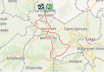

Length
12.6 km

Max alt
164 m

Uphill gradient
217 m
Km-Effort
15.5 km

Min alt
68 m

Downhill gradient
218 m
Boucle
Yes
Creation date :
2022-04-02 09:22:26.643
Updated on :
2022-04-02 10:07:47.581
3h31
Difficulty : Difficult
0m
Difficulty : Very easy

FREE GPS app for hiking
 SityTrail
IGN / Geographical institutes
SityTrail Plus
The world is yours!
About
Trail Walking of 12.6 km to be discovered at Ile-de-France, Val-d'Oise, La Chapelle-en-Vexin. This trail is proposed by serge.guerroult.
Description
circuit dans la campagne du vexin Français
Positioning
Country:
France
Region :
Ile-de-France
Department/Province :
Val-d'Oise
Municipality :
La Chapelle-en-Vexin
Location:
Unknown
Start:(Dec)
Start:(UTM)
407582 ; 5448576 (31U) N.
Comments